Photos
Enter a word or phrase to perform a general search across all records in the Photos catalog. You can also browse records in the catalog without performing a search.
Search Tips
- Searches are not case sensitive.
- Searching for multiple words connects them with OR by default. Matching records can contain any of the words.
- Connect multiple words with AND if you only want to see records containing both words.
- Use quotation marks to search for a phrase.
- Place an asterisk (*) at the end of a word as a wildcard.
5756 results found. Records searched: 5756
-
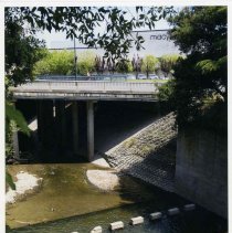
P6964 - Las Trampas Creek going east under Broadway Plaza. Taken from California Blvd. bridge just south of Bothello Dr. Year not indicated- probably early 2000's.
Broadway Plaza California Blvd. Bothello Dr. Las Trampas Creek
Record Type: Photo
-
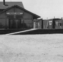
P6967 - W. C. TRAIN STATION. SOUTHERN PACIFIC PROPERTY
Walnut Creek Train Station Southern Pacific 1970
Record Type: Photo
-
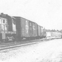
P6967.1 - WALNUT CREEK TRAIN STATION - SO. PACIFIC RR TRAIN STATION BEFORE BEING MOVED COPY
trains Walnut Creek Train Station Southern Pacific 1965
Record Type: Photo
-
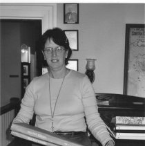
P6970.1 - PRISCILLA COUDEN, DIRECTOR 2003 IN HISTORY ROOM WORKING ON THE "NEWSPAPER PROJECT" SEE 6970.2
Couden WCHS History Room 2003
Record Type: Photo
-
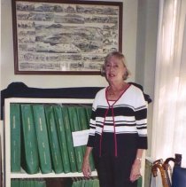
P6970.2 - AUDREY VEREEGE, HISTORIAN, IN THE HISTORY ROOM WORKING TO THE "NEWSPAPER PROJECT" tHE WC jOURNAL WAS BEING COPIED ONTO MICROFILM AS PART OF A NATIONAL PROJECT IN CONJUNCTION WITH THE UC BERKELEY LIBRARY
Verrege WCHS History Room 2003
Record Type: Photo
-
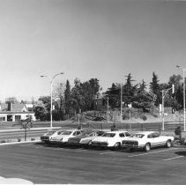
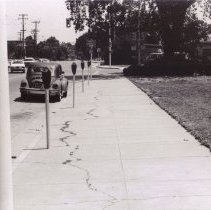
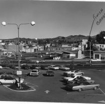
P6975.1 - Civic St. looking east at Broadway.
Civic Dr. Broadway Plaza automobile 1978
Record Type: Photo
-
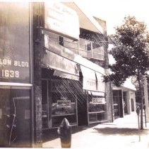
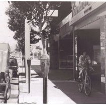
P6975.3 - Pawn shop located left of Reinhart's on Main St. The shop went out of business and the New World Barber Shop opened in the late 1970s. Looking towards the south.
Reinhart's pawn shop New World Barber Shop Main St. 1978
Record Type: Photo
-
P6975.4 - Reinhart's Jewelers located on Main St. Late 1970s or early 1980s. Looking north towards Civic. MICHAEL Reinhart OWNED THE WHOLE BLDG AND RENTED 3 OTHER STORES.. FAMILY LIVED OFF EAST CHERRY LANE FAMOUS CLOCK DOES NOT SHOW WELL.
Reinhart's Jewelers Main St. automobile bicycle 1978
Record Type: Photo
-
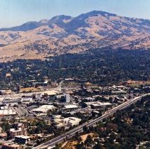
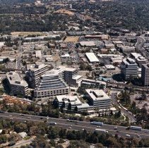
P6977.1 - LOOKING EAST AT MT DIABLO OVER 680 FREEWAY. OLYMPIC ON LEFT, LARGE FLAT ROOF ON LEFT IS SIMONS HARDWARE, REPLACED BY PLAZA ESQUELA
aerial Mt. Diablo Hwy. 680 Simons Mt. Diablo Blvd. 1990
Record Type: Photo
-
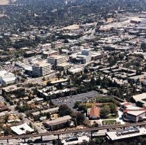
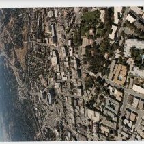
P6977.2 - WC AERIAL LOOKING EAST FROM ABOVE BART TRACKS Per back of photo: Lacassie Ave. on left Presbyterian Church in foreground Lescher Regional Theatre Center, grey building at center
Lacassie Ave. Walnut Creek Presbyterian Church Lescher Regional Theatre Center aerial 1990
Record Type: Photo
-
P6977.3 - LOOKING SO EAST ABOVE 680 FREEWAY. MT DIABLO ON RIGHT CENTER. TRINITY AVE ON LEFT
Mt. Diablo Blvd. Broadway Plaza Trinity Ave. Hwy. 680 aerial 1990
Record Type: Photo
-
P6977.4 - "GOLDEN TRIANGLE" BLDGS IN FOREGROUND LOOKING EAST FROM TRINITY Per back of photo: Golden Triangle Homestead Hill John Muir Hospital Ygnacio Valley Rd. BART parking lot Hwy. 680
Golden Triangle Homestead Hill John Muir Hospital Ygnacio Valley Rd. BART parking lot Hwy. 680 aerial 1990
Record Type: Photo
-
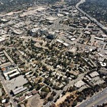
P6977.5 - LOOKING EAST OVER YGNACIO VALLEY RD AND BAART PARKING LOT. lOT WAS TURNED IINTO APARTMENTS ABOUT 2015. Seen in photo per back of photo: Mt. Diablo Blvd. Walnut Creek Presbyterian Church BART Oakland Blvd. Ygnacio Valley Rd. Lacassie Ave. California Blvd. Main St. Walnut Creek Motel Target Walnut Creek Library
Mt. Diablo Blvd. Walnut Creek Presbyterian Church BART Oakland Blvd. Ygnacio Valley Rd. Lacassie Ave. California Blvd. Main St. Walnut Creek Motel Target Walnut Creek Library aerial 1990
Record Type: Photo
-
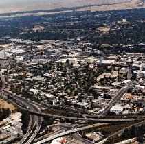
P6977.6 - LOOKING NO EAST OVER WALNUT CREEK SHOWS 24/680 INTERCHANGE. BOTTOM OF PHOTOIS 24 GOING TO LAFAYETTE Seen in photo per back of photo: John Muir Hospital Mt. Diablo Blvd. Lesher Regional Center of Arts Boulevard Way Hwy. 24 BART Hwy. 680 Ygnacio Valley Rd.
John Muir Hospital Mt. Diablo Blvd. Lesher Regional Center of Arts Boulevard Way Hwy. 24 BART Hwy. 680 Ygnacio Valley Rd. aerial 1990
Record Type: Photo
-
P6977.7 - LOOKING EAST FROM ABOVE MT. DIABLO BLVD. ST MARY'S CHURCH, RED ROOF IN FOREGROUND Seen in photo per back of photo: Lucky Market Long's Drugs Simon's Hardware St. Mary's Church California Blvd. Botelho Ave. Olympic Blvd. Mt. Diablo Blvd. Civic Dr.
Lucky Market Long's Drugs Simon's Hardware St. Mary's Church California Blvd. Botelho Ave. Olympic Blvd. Mt. Diablo Blvd. Civic Dr. aerial 1990
Record Type: Photo
-
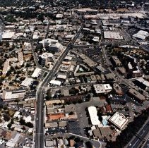
P6977.8 - Looking west towards Hwy. 24- taken from helicopter around 1990. Seen in photo per back of photo: Lincoln Ave. Mt. Diablo Blvd. Hwy. 680 Hwy. 24 California Blvd. Lesher Regional Center Civic Dr. Walnut Creek Library
Lincoln Ave. Mt. Diablo Blvd. Hwy. 680 Hwy. 24 California Blvd. Lesher Regional Center Civic Dr. Walnut Creek Library aerial 1990
Record Type: Photo
-
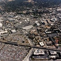
P6977.9 - LOOKING NORTH FROM ABOVE BROADWAY PLAZA , LARGE PARKING LOT WAS RAZED IN 2014 AND MADE INTO A LARGER STRUCTURE WHEN ALL THE BUILDINGS SHOWN TO THE LEFT OF THE LOT WERE RAZED AND NEW ONES BUILT. ALL THE BUSINESSES HAD TO FIND NEW LODGINGS OR GO OUT OF BUSINESS. BIG PARKING ON LEFT BEHIND i. MAGNIN'S WAS MADE INTO A PARKIING GARAGE IN THE 1990s, Seen in photo per back of photo: Broadway Plaza Bullock's Nordstroms Main St. Locust Ave. California Blvd. Civic Dr. Mt. Diablo Blvd.
Broadway Plaza Bullock's Nordstroms Main St. Locust Ave. California Blvd. Civic Dr. Mt. Diablo Blvd. aerial 1990
Record Type: Photo
-
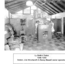
P6981 - Interior of salon 1946-1949 shows hair driers and old style permanent wave machine with curlers hanging from electrical wires. Two women, sisters, Lila Woodworth and Bessy Newell owners/operators
Woodworth Newell Lu Belle's Salon 1946
Record Type: Photo
-
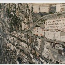
P6982.1 - PART OF A SERIES 1-4 OF LOCUST, MT. DIABLO BLVD, AND OLYMPIC IN PREPARATION OF THE REBUILDING OF THE ENTIRE BLOCK Seen per back of photo: Southeast corner of California Blvd. and Mt. Diablo Blvd.- in 2007 was rebuilt into a Cost Plus Steep-roofed building behind the Union 76 gas station was an International House of Pancakes, then Big 5 Sporting goods. Next to the "Wheel/Brake"shop is the Dole House which was converted into a real estate office in the 1990's. Parking lot in foreground belonged to Longs Drugs. In 2010, Longs Drug sold to CVS Drugs (still CVS Drugs, Genoa Delicatessen, Phillz Coffee, and BBVA Compass Bank as of 06/2020) Where Union 76 gas station stands, it became a Cost Plus Imports around 2007. Chevron gas station at left of House of Pancakes, is still there as of 2020
California Blvd, Mt. Diablo Blvd. Cost Plus Imports Union 76 International House of Pancakes Big 5 Longs Drugs CVS Drugs Chevron automobiles 1978
Record Type: Photo
-
P6982.2 - LOOKING EAST FROM LONGS PARKING LOT AT CALIFORNIA AND MT DIABLO, GAS STATION BECAME COST PLUS, HILL AND HOUSE DEMOLISHED IN 2003
California Blvd. Mt. Diablo Blvd. Longs Drugs automobiles 1978
Record Type: Photo