Search Term Record
Metadata
Name |
aerial photo |
Related Records
-
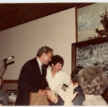
2018.120.3 - Fran and Bob Schroder in front of 1928 aerial photo of Walnut Creek. Year unknown.
Schroder, Bob Schroder, Fran aerial photo Walnut Creek 1928
Record Type: Photo

-
2018.120.4 - Fran and Bob Schroder in front of 1928 aerial photo of Walnut Creek at an event. Year unknown.
Schroder, Bob Schroder, Fran aerial photo Walnut Creek 1928
Record Type: Photo
-
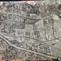
2018.52.1 - 3'x3' aerial photo of North Walnut Creek taken June 6, 1978 by unknown source. Photo was recovered from the gold room closet when cleaning out maps. Photo has not been scanned- attached photo is a photograph of the map.
aerial photo Walnut Creek 1978
Record Type: Photo
-
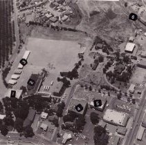
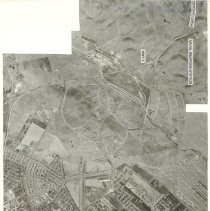
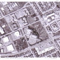
P1745A - Aerial photo of Walnut Creek School about 1948 - 1. First building 1912, 2. Auditorium 1929, 3. Pre-fab buildings 1947, 4. Jackson Furniture Co., 5. Veteran's Memorial Building, 6. Sacramento Northern R.R. , 7. Main Street.
Walnut Creek School 1948 aerial photo Jackson Furniture Co. Veterans Memorial Building Sacramento Northern R.R. Main Street
Record Type: Photo
-
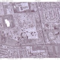
P1745B - Aerial of Walnut Creek school site 1954. 1. PG&E sub-station, 2. Southern Pacific Railroad
Walnut Creek school site aerial photo 1954 P.G. & E. Sub-station Sacramento Northern r.w.
Record Type: Photo
-
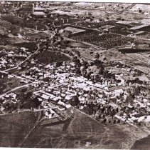
P3881 - Downtown Walnut Creek, looking east, aerial 1930. See also P3881B.
aerial photo Walnut Creek 1930
Record Type: Photo
-
P6080 - Aerial view of Walnut Creek showing Main St. - Danville Blvd. October 4, 1957.
aerial photo Walnut Creek 1957
Record Type: Photo
-
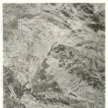
P6090 - Aerial photo of the Concord Naval Weapons Station, CA Highway 4. October 4, 1957
aerial photo Concord Naval Weapons Station, CA Highway 4 1957
Record Type: Photo
-
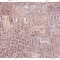
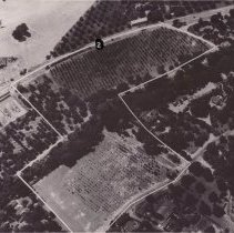
P6236 - Aerial Photo of Ygnacio Valley Road & Oak Grove Rd. 1973. See also P6238A, P6238B, P6237
Shadelands Ranch 1973 aerial photo Peach Willow Citrus Lennon Lane Wiget Lane Oak Grove Road Ygnacio Valley Road
Record Type: Photo
-
P6237 - Aerial Photo of Ygnacio Valley Road & Oak Grove Blvd. See also P6238A, P6238B, P6237, P6236., 1973.
Shadelands Ranch 1973 aerial photo Peach Willow Citrus Lennon Lane Wiget Lane Oak Grove Road Ygnacio Valley Road
Record Type: Photo
-
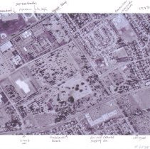
P6238A - Aerial photos of the area around Shadelands Ranch, 1973. Includes Ygnacio Valley High School, Valle Verde Elementary, the canal, Encina Grande Shopping Center, Wiget Lane, Oak Grove Road, Ygnacio Valley Road. 1973. See also P6238B.
aerial photo Shadelands Ranch 1973 Ygnacio Valley High School Valle Verde Elementary canal Encina Grande Shopping Center Wiget Lane Oak Grove Road Ygnacio Valley Road
Record Type: Photo
-
P6238B - Aerial photos of the area around Shadelands Ranch, 1973. Includes Peachwillow Ln., Citrus Ave, Ygnacio Valley Road, Oak Grove Road, Lennon Lane, Wiget Ln.. 1973. See also P6238A.
Shadelands Ranch 1973 aerial photo Peach Willow Citrus Lennon Lane Wiget Lane Oak Grove Road Ygnacio Valley Road
Record Type: Photo