Search Term Record
Metadata
Name |
Trinity Ave. |
Related Records
-
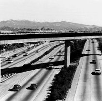
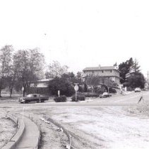
2022.013.002 - Highway 680 from Trinity Ave. overpass facing south, 1970.
Hwy. 680 Trinity Ave. automobile 1970
Record Type: Photo
-
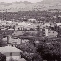
P6312A - Walnut Creek streets, looking east from Trinity Ave. Dated 1976. Castlewood Apartments can be seen on Mt. Pisgah at center right BART tracks running in lower foreground. Walnut Creek Presbyterian Church tower can be seen just behind BART tracks towards center right. To the left above the telephone pole is the Walnut Heights neighborhood on Marshall Dr. To the left of Walnut Heights, at the very edge of photo is John Muir Hospital
Walnut Creek Presbyterian Church Trinity Ave. Marshall Dr. Walnut Heights John Muir Hospital BART 1976
Record Type: Photo
-
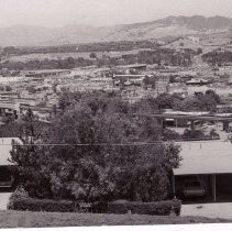
P6312B - Walnut Creek streets looking east from Trinity Ave. Dated 1976. Oval sign at dead center is the sign for Gemco at the corner of Main St. and Ygnacio Valley Rd. "Hat"-shaped roof to right of Gemco sign is a Sizzler restaurant. John Muir hospital can be seen peeking out to the right of the hill behind the Sizzler. Fidelity Savings is large building at left. BART tracks running across lower center.
Trinity Ave. Main St. Ygnacio Valley Rd. Gemco, Sizzler Fidelity Savings BART 1976
Record Type: Photo
-
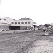
P6330F - Construction of California Blvd at the intersection of Tinity Ave.
California Blvd. Trinity Ave. 1966 Construction
Record Type: Photo
-
P6341C - Construction of California Blvd. California Blvd. at Civic Dr. Trinity Ave. 1960-63. Walnut Growers Association/Walnut Processing Plant
California Blvd. Civic Dr. Trinity Ave. construction Walnut Growers Association Walnut Processing Plant automobiles 1960-1963
Record Type: Photo
-
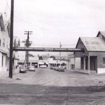
P6341D - Contra Costa Walnut Grower's Association.
California Blvd. Civic Dr. Trinity Ave. construction Walnut Growers Association Walnut Processing Plant automobiles 1960-1963
Record Type: Photo
-
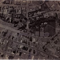
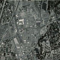
P6352A - Aerial view (negative) of Civic crossing Broadway thru Main details noted on back of photo: Ygnacio Valley Rd. WC School Admin. Bldg. Monticello Mano Apartments Civic Dr. The Nuthouse Theatre (formerly the WC Gower's Association) California Blvd. WC Grammar School Trinity Ave. Pier One Imports (formerly Bekins Storage) Newell Ave.
aerial Ygnacio Valley Rd. WC School Admin. Bldg. Monticello Mano Apartments Civic Dr. The Nuthouse Theatre WC Gower's Association California Blvd. WC Grammar School Trinity Ave. Pier One Imports Bekins Storage Newell Ave. 1970
Record Type: Photo
-
P6357A - Looking over area around North Main St and Ygnacio Valley Rd. Dated 8/20/75. Details from back of photo seen in image #3: Civic Dr. Ygnacio Valley Rd. Gemco/Target BART Sation Trinity Ave.
Civic Dr. Ygnacio Valley Rd. Gemco/Target BART Sation Trinity Ave. aerial 1975
Record Type: Photo
-
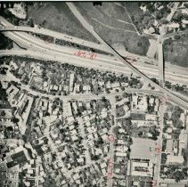
P6358Q - Trinity Ave - Shuey area in Walnut Creek dated 4-3-74. Trinity Ave. Oakland Blvd. Oakdale Rd. Almond Ave. Shuey Presbyterian Church
Trinity Ave. Oakland Blvd. Oakdale Rd. Almond Ave. Shuey Presbyterian Church aerial 1974
Record Type: Photo
-
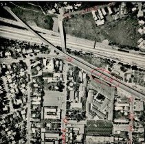
P6358U - Aerial view north of downtown Walnut Creek - Trinity Ave on right side of photo, shows I 680 north of Walnut Creek interchange - dated4-3-74. Hwy. 680 Oakland Blvd. Terraace Rd. Trinity Ave. Shuey Area
Hwy. 680 Oakland Blvd. Terraace Rd. Trinity Ave. Shuey Area aerial 1974
Record Type: Photo
-
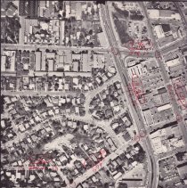
P6358V - Area of Trinity, Locust, California Blvd in Walnut Creek dated 4-3-74. California Blvd. Locust St. East St. Civic Dr. Trinity Ave.
California Blvd. Locust St. East St. Civic Dr. Trinity Ave. aerial 1974
Record Type: Photo
-
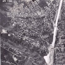
P6380P - Aerial photograph dated April 7, 1959. Shows NW Walnut Creek, I-680., Trinity Ave. and Oakvale Ter. can be seen in lower right corner
Trinity Ave. Oakvale Ter. Hwy 680 aerial 1959
Record Type: Photo
-
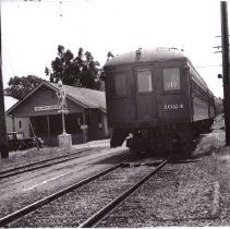
P6904.3 - Oakland, Antioch & Eastern Railroad car. Shows the station where children caught the traiin to Mt. Diablo High School, next to the Walnut Grower's Building. Street TO LEFT is now Trinity Ave.
Oakland, Antioch & Eastern train station 1950 Trinity Ave.
Record Type: Photo