Search Term Record
Metadata
Name |
Recreation Building |
Related Records
-
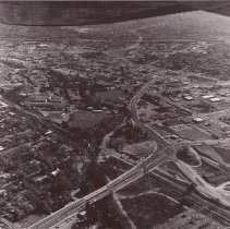
P6352B - Aerial view Ygnacio Valley crossroad Walnut Blvd. (map on back) - 1970 details noted on back of photo: Hwy. 24 Hwy 680 Mt. Diablo Blvd. Bonanza St. Newell Ave. WC Grammar School Civic Dr. Civic Park Recreation Building library Cameron Dr. Ygnacio Valley Rd. railroad tracks Civic Park baseball armory building Walnut Creek Mt Pisgah (prior to leveling for apartments)
aerial Hwy. 24 Hwy 680 Mt. Diablo Blvd. Bonanza St. Newell Ave. WC Grammar School Civic Dr. Civic Park Recreation Building library Cameron Dr. Ygnacio Valley Rd. railroad tracks Civic Park baseball armory building Walnut Creek Mt Pisgah
Record Type: Photo
-
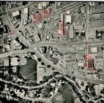
P6352C - Aerial view - Walnut Creek sstreets (Civic and Broadway) - map on back - 1970 details noted on back of photo: Broadway Plaza Lucky's (then Bullocks, then Nordstroms) Walnut Creek Civic Park Recreation Building Civic Arts Education building armory building Cameron Rd. Standard Oil (Chevron Station) Lupai's Market
aerial Broadway Plaza Lucky's (then Bullocks, then Nordstroms) Walnut Creek Civic Park Recreation Building Civic Arts Education building armory building Cameron Rd. Standard Oil (Chevron Station) Lupai's Market 1970
Record Type: Photo
-
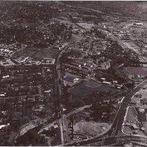
P6358O - Aerial photo of Broadway and Civic Dr in Walnut Creek dated 4-3-74.. Library Civic Park Recreation Building Civic Arts Broadway Main St. Civic Dr. The Walnut Creek Department of Motor Vehicles
Library Civic Park Recreation Building Civic Arts Broadway Main St. Civic Dr. The Walnut Creek Department of Motor Vehicles aerial 1974
Record Type: Photo