Search Term Record
Metadata
Name |
Hwy. 680 |
Related Records
-
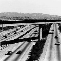
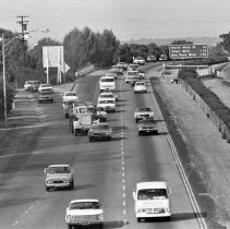
2022.013.002 - Highway 680 from Trinity Ave. overpass facing south, 1970.
Hwy. 680 Trinity Ave. automobile 1970
Record Type: Photo
-
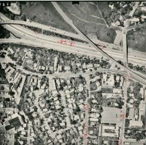
2022.013.004 - Hwy. 680 from Geary-Treat overpass facing south, 1970.
Hwy. 680 Geary Rd. Treat Blvd. automobiles 1970
Record Type: Photo
-
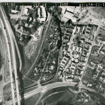
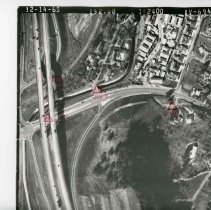
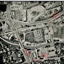
P6354N - Interchange of I 680 and Rudgear Road.. Photo dated 12/14/65.
Rudgear Rd. Hwy. 680 Southern Pacific Railroad aerial 1965
Record Type: Photo
-
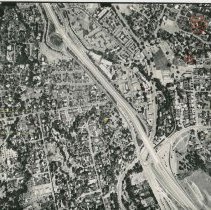
P6354O - Another view of interchange of i680 and Rudgear Road. Photo dated 12/14/65. Location points are listed on back of photo with details regarding elevations and slope on back of photo as seen in image 3
Rudgear Rd. Hwy. 680 aerial 1965
Record Type: Photo
-
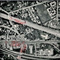
P6357F - Area of Newell Ave. and San Miguel Dr. in Walnut Creek. Dated 8/20/75. Details from back of photo as seen in image #3: Newell Ave. San Miguel Dr. Hwy. 680 Rudgear Rd. Camel, Ln. Lancaster Rd. Hillview Dr. railroad tracks Rudgear off ramp
Newell Ave. San Miguel Dr. Hwy. 680 Rudgear Rd. Camel, Ln. Lancaster Rd. Hillview Dr. railroad tracks Rudgear off ramp aerial 1975
Record Type: Photo
-
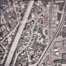
P6358A - Photo showing I680, California Blvd, Bart tracks at bottom of photo. Details from back of photo as seen in image #3: California Blvd. Hwy. 680 Parkside Dr. San Juan Ave. BART
California Blvd. Hwy. 680 Parkside Dr. San Juan Ave. BART aerial 1974
Record Type: Photo
-
P6358D - BART tracks, North Main St, I680 freeway on right Details from back of photo: BART Hwy. 680 California Blvd. Main St. Riviera Ave. Parkside Dr. Golden Triangle
BART Hwy. 680 California Blvd. Main St. Riviera Ave. Parkside Dr. Golden Triangle aerial 1974
Record Type: Photo
-
P6358I - Ygnacio Valley Rd west from Homestead toward I680 freeway. Hwy. 680 Ygnacio Valley Rd. Civic Dr. Homestead Ave. Chevron PG&E Howard Estate
Hwy. 680 Ygnacio Valley Rd. Civic Dr. Homestead Ave. Chevron PG&E Howard Estate aerial 1974
Record Type: Photo
-
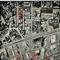
P6358R - I680, California Blvd, Locust St. area north of Mt. Diablo Blvd in Walnut Creek dated 4-3-74. Hwy. 680 California Blvd. Locust St. Bonanza St. Shuey Ave. Nut House Theatre
Hwy. 680 California Blvd. Locust St. Bonanza St. Shuey Ave. Nut House Theatre aerial 1974
Record Type: Photo
-
P6358U - Aerial view north of downtown Walnut Creek - Trinity Ave on right side of photo, shows I 680 north of Walnut Creek interchange - dated4-3-74. Hwy. 680 Oakland Blvd. Terraace Rd. Trinity Ave. Shuey Area
Hwy. 680 Oakland Blvd. Terraace Rd. Trinity Ave. Shuey Area aerial 1974
Record Type: Photo
-
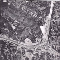
P6380Q - Aerial photograph dated April 7, 1959. Shows NW Walnut Creek, Buena Vista Elementary School, Hwy. 680
Buena Vista School Hwy. 680 aerial 1959
Record Type: Photo
-
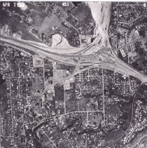
P6380R - Aerial photograph dated April 7, 1959. Shows 680/24 interchange. Boulevard Way in lower right corner, Mt. Diablo Blvd. passing under the interchange in lower right corner, Walnut Creek Presbyterian Church in upper right corner
Hwy. 680 State Hwy 24 Boulevard Way Mt. Diablo Blvd. aerial 1959
Record Type: Photo
-
P6380S - Aerial photograph dated April 7, 1959. Shows Hwy. 680/24 interchange, Olympic Blvd. in lower right corner
Hwy. 680 State Hwy 24 Olympic Blvd. aerial 1959
Record Type: Photo
-
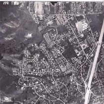
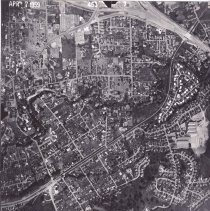
P6380T - Aerial photograph dated April 7, 1959. Shows Saranap area. Parkmead Elementary School center right, freeway construction.
Parkmead Elementary Hwy. 680 State Hwy 24 Saranap aerial 1959
Record Type: Photo
-
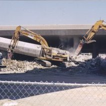
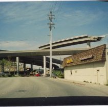
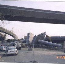
P6955.1 - A GROUP OF 6 PHOTOS FOR THE 680 FREEWAY "FLY-OVER AND DESTRUCTION.4/17/1999 TAKEN FROM BOULEVARD WAY BY CONTRA COSTA APPLIANCE AT ENTRANCE TO FREEWAY 24. IN ORDER TO BUILD A NEW CONNECTOR FROM CONCORD TO DUBLIN, AN EXTREMELY HIG CONNECTOR WAS BUILT CALLED THE "FLYOVER'. IT WAS EVENTUALLY DISMANTELED.. IT WAS SO HIGH , SOME POEPLE WERE FEARFUL TO DRIVE ON IT.. See also series 2017.65.1a-1p, black and white photo series of the same event.
Hwy. 680 construction Boulevard Way Contra Costa Appliance 1999
Record Type: Photo
-
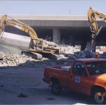
P6955.2 - DESTRUCTION (REMOVAL) OF THE 680 FREEWAY "FLYOVER" TAKEN 4/17/1999 See also series 2017.65.1a-1p, black and white photo series of the same event.
Hwy. 680 construction Boulevard Way 1999
Record Type: Photo
-
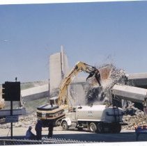
P6955.3 - DESTRUCTION OF THE 680 FREEWAY '"FLYOVER" 4/17/199 SHOWS EQUIPMENT 680 See also series 2017.65.1a-1p, black and white photo series of the same event.
Hwy. 680 construction Boulevard Way 1999
Record Type: Photo
-
P6955.4 - DESTRUCTION OF THE 680 FREEWAY "FLYOVER" SEE 6955 FOR DESCRIPTION See also series 2017.65.1a-1p, black and white photo series of the same event.
Hwy. 680 construction Boulevard Way 1999
Record Type: Photo
-
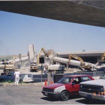
P6955.5 - DESTRUCTION OF 680 FREEWAY "FLYOVER" SEE DESCRIPTIONN ON 6955 See also series 2017.65.1a-1p, black and white photo series of the same event.
Hwy. 680 construction Boulevard Way 1999
Record Type: Photo
-
P6955.6 - DESTRUCTION OF 680 FREEWAY 'FLYOVER" SEE 6955 FOR DESCRIPTION See also series 2017.65.1a-1p, black and white photo series of the same event.
Hwy. 680 construction Boulevard Way 1999
Record Type: Photo