Search Term Record
Metadata
Name |
1965 |
Related Records
-
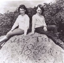
P3042A - Tice Rock carved by James W. Tice in 1855. Dale and Lora Landregan seated on top of rock. Taken 1965. Located in Rossmoor at the top of the hill above the cactus garden.
Landregan Tice, James Tice Rock Rossmoor 1965
Record Type: Photo
-
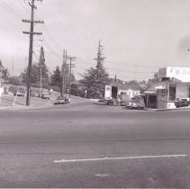
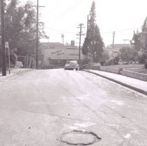
P6310A - Mt. Diablo Blvd. at Bonanza St. Gateway office building on right corners later. Businesses pictured: on left Regal gas station, on right, Mr. Victor Hair Salon, Engle Realty & Investment Co., Payless Cleaners, Diablo Printing, October 28, 1965
Mt. Diablo Blvd. Bonanza St. Regal Mr. Victor Hair Salon Engle Realty & Investment Co. Payless Cleaners Diablo Printing automobiles 1965
Record Type: Photo
-
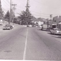
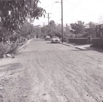
P6310B - Looking down at Bonanza from Mt. Diablo Blvd.. Regal gas station on left (later Simco gas) White house at center would become Dr./Dentist office in the 1980's - 2005. Sharpe Avenue to left. The Diablo Printing, and International Interiors Furniture on right. October 28, 1965.
Mt. Diablo Blvd. Bonanza St. Regal Diablo Printing International Interiors Furniture automobiles 1965
Record Type: Photo
-
P6310C - Bonanza St. towards Mt. Diablo Blvd., October 28, 1965. International Interiors Furniture can be seen at center.
Mt. Diablo Blvd. Bonanza St. International Interiors Furniture automobiles 1965
Record Type: Photo
-
P6330Z - California Boulevard under construction maybe in Shuey area, October 28, 1965.
California Blvd. Automobiles 1965
Record Type: Photo
-
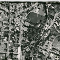
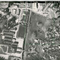
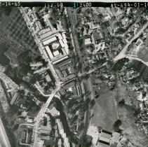
P6354A&B - Civic Drive and north Broadway showing Civic park, Walnut Creek library and surrouding area. - 12-14-65. details listed on back of photo: Lincoln Ave. Broadway Plaza library Civic Park Recreation Building Civic Dr.
Ygnacio Valley Rd. Civic Dr. Broadway Plaza Civic Park library Lincoln Ave. 1965 aerial
Record Type: Photo
-
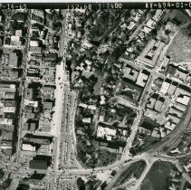
P6354C - North Broadyway From Lincoln - top of photo - to Mt. Diablo Blvd near bottom of photo. details listed on back of photo: Mt. Diablo Blvd. Broadway Plaza Main Street
Mt. Diablo Blvd. Broadway Plaza Main Street aerial 1965
Record Type: Photo
-
P6354C&D - North Broadway from Lincoln to Mt. Diablo Blvd details listed on back of photo: Mt. Diablo Blvd. Broadway Plaza Main St.
Mt. Diablo Blvd. Broadway Plaza Main St. aerial 1965
Record Type: Photo
-
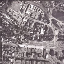
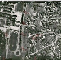
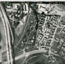
P6354E - Location points are listed on back of photo with details regarding elevations and slope on back of photo as seen in image 3 other details listed on back: Mt. Diablo Blvd. Newell Ave. Broadway Plaza Penny's Lucky's Cement Plant Railroad Station
Mt. Diablo Blvd. Newell Ave. Broadway Plaza Penny's Lucky's Cement Plant Railroad Station aerial 1965
Record Type: Photo
-
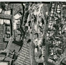
P6354F - Broadway Plaza shopping center in foreground - 12/14/65 details from back of photo: Safeway Market Capwell's I. Magnin parking lot Lucky's Market Walker Ave.
Safeway Market Capwell's I. Magnin parking lot Lucky's Market Walker Ave. Broadway Plaza aerial 1965
Record Type: Photo
-
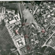
P6354G - Portion of Broadway Plaza shopping center below red triangles. Red triangles located on Southern Pacific Train tracks - this area is now north Broadway. Photo dated 12/14/65. Location points are listed on back of photo with details regarding elevations and slope on back of photo as seen in image 3
Broadway Plaza Southern Pacific Railroad aerial 1965
Record Type: Photo
-
-
P6354I - Appears to be Southern Pacific Road Tracks - this area is now South Broadway. dated 12/14/65 Red triangles located on Southern Pacific Train tracks down center- this area is now north Broadway. Photo dated 12/14/65. Location points are listed on back of photo with details regarding elevations and slope on back of photo as seen in image 3
aerial Southern Pacific Railroad train 1965 Broadway Plaza
Record Type: Photo
-
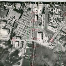
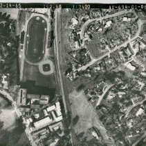
P6354J - Southern Pacific Rail Road tracks in center of picture - las Lomas high Chool playing field to left of tracks. Now the site of South Broadway. taken 12/14/65
Las Lomas High School Southern Pacific Railroad Main Street aerial 1965
Record Type: Photo
-
P6354K - Southern Pacific Railroad tracks in center of picture. Dated 12/14/65 Location points are listed on back of photo with details regarding elevations and slope on back of photo as seen in image 3
Southern Pacific Railroad aerial 1965
Record Type: Photo
-
P6354M - No description given. Probably I680 on left side of photo, Southern Pacific Railroad tracks down center. Location points are listed on back of photo with details regarding elevations and slope on back of photo as seen in image 3
aerial 1965
Record Type: Photo
-
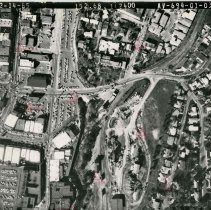
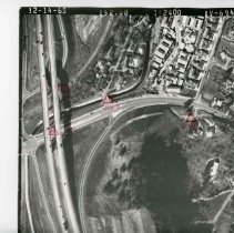
P6354N - Interchange of I 680 and Rudgear Road.. Photo dated 12/14/65.
Rudgear Rd. Hwy. 680 Southern Pacific Railroad aerial 1965
Record Type: Photo
-
P6354O - Another view of interchange of i680 and Rudgear Road. Photo dated 12/14/65. Location points are listed on back of photo with details regarding elevations and slope on back of photo as seen in image 3
Rudgear Rd. Hwy. 680 aerial 1965
Record Type: Photo
-
P6652 - Larkey Park in Walnut Creek, 1965. Original home of the local water department pumping station. Building seen was the first home of the Lindsey Wildlife Museum.
Larkey Park pumping station Lindsey Wildlife Museum 1965
Record Type: Photo
-
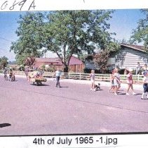
P6689A - Children lining up to participate in parade, July 4, 1965. Woodlands neighborhoos, cornewr of Citrus Ave. and Oak Rock Rd.
Westfall, Howard E. 4th of July parade children Woodlands Citrus Ave. Oak Rock Rd. 1965
Record Type: Photo